As a data-driven agency, the United States Geological Survey (USGS) brings science for decision-making to the San Antonio Urban Waters Federal Partnership. As a member of the Federal Partnership, the USGS is helping inform management agencies in the region about the effects of urbanization by monitoring water quality and water quantity. Taking the data-driven approach, Doug Schnoebelen—USGS Oklahoma-Texas Water Science Center South Texas Branch Chief—asserts, “[you] can’t manage what you don’t monitor.”

Since 1959, urban development has occurred over the Edwards Aquifer Recharge Zone in San Antonio, TX. Urban development threatens the quality of water being added to the aquifer because of increased stormwater runoff and decreased groundwater infiltration. Photos: USGS via Google Earth
San Antonio Basin, Edwards Aquifer System
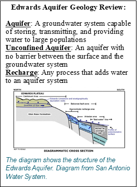
The San Antonio River Basin begins in Bexar County, Texas, where the sub-humid to semi-arid climate fluctuates between wet and dry conditions, and flash flooding is common. The underlying carbonate (limestone) rocks in the region are easily dissolved, creating networks for water to flow quickly into and through the subsurface. This type of geologic setting is characterized as karst topography and results in prominently interconnected networks of surface and groundwater resources. The Edwards Aquifer—a groundwater source that feeds the San Antonio River—emerges as springs in midtown and near San Antonio. Historically, these springs were inhabited by the Coahuiltecans, the collective name of the people indigenous to the San Antonio area. The pristine waters offered life to the native dwellers and attracted more and more European settlers, who began settling the area in the 17th century. Evidence of sophisticated water infrastructure—known as the acequias—is still present today at the San Antonio Missions.
Today, San Antonio is one of the largest cities in the United States with a population that is expected to double in the next twenty years. By protecting the seven different endangered species found in the Basin, the Federal Endangered Species Act helps to ensure there is sufficient water in the Edwards Aquifer so that major springs will not go dry, as they did in years past. Clean, abundant water is essential for both human and wildlife populations to grow. Several major agencies help to preserve and protect the water resources within Bexar County. These include the San Antonio Water System (SAWS), the San Antonio River Authority, and the Edwards Aquifer Authority as well as local governments, community groups and nonprofit organizations. As a way to ensure a sustainable water supply, SAWS expanded to include eight different sources for water in addition to the Edwards Aquifer system.
San Antonio River Basin Urban Waters Federal Partnership
What started in 2011 as a multi-agency partnership to restore ten miles of the San Antonio River through San Antonio Missions National Park has since expanded with local and Federal support. By 2014, the San Antonio River Basin within Bexar County became a designated Urban Waters Federal Partnership Location. In 2015, with the designation of the San Antonio Missions as a World Heritage Site, efforts to restore the river gained further visibility as an important contribution to the overall cultural significance of the region. In addition to preserving the Missions, the Federal Partnership works to reconnect communities to their urban rivers through restoration at Elmendorf Lake Parks, Westside Creeks, and Olmos Basin Aquatic system. Today, the partnership extends to more agencies and organizations within Bexar County and includes such partners as the USGS.

Left: San Antonio River flow is supported by springs of the Edwards Aquifer near the city center. The USGS monitors water quantity and quality in urban locations across Bexar County as part of the Urban Hydrology Network. Right: The recharge zone of the Edwards Aquifer is located in urbanized areas of San Antonio. Images of the aquifer adapted from Musgrove and others, 2016 Photo: USGS
Urban Hydrology Network
Leveraging Urban Waters Federal Partnership Cooperative Matching Funds and in cooperation with SAWS, San Antonio River Authority, the City of San Antonio, and the USGS have created an Urban Hydrology Network (UHN) within Bexar County. The USGS and its partners want to understand relationships between surface-water runoff, groundwater recharge, and water quality, particularly in the urban sections of the Edwards Aquifer recharge zone.
“We want to understand how much water we have and how to monitor and predict the integrity of water quality into the future.”
Stephen Opsahl, USGS Oklahoma-Texas Water Science Center.
These efforts will provide water resource managers with the data and information they need in order to determine if water protection measures are needed and what types of measures might be appropriate to ensure that the city’s water supply remains clean and plentiful. The technology required to do this is sophisticated; and the data collected from these sites and the information gleaned from these data are invaluable to the overall goals of the San Antonio River Basin Urban Waters Federal Partnership.
 Continuous monitoring at the UHN sites began in 2013 and continued through 2019 at both groundwater and surface water monitoring locations. The network also includes “super gages” at which groundwater levels, stream flow, and water quality are all being measured in a single location. Real-time water-quality properties include temperature, dissolved oxygen, specific conductance, nitrate, pH, and fluorescent dissolved organic matter. Other constituents—such as nutrients, pesticides, and isotopes— are measured in water samples collected quarterly.
Tracking the presence and quantity of constituents that degrade water quality in the recharge areas provides important information about the vulnerability of the deeper groundwater, which is the source of drinking water for San Antonio residents. Analysis of data from the UHN indicates that stormwater runoff from flash floods caused a measurable increase in groundwater levels in the unconfined region of the aquifer in a matter of hours to days. At select sites, the UHN identified 33 different pesticides that were detected at least once across all the testing sites, with nitrate and pesticides occurring at higher concentrations in the more urbanized areas. [Find more information about sources and effects of pesticides and nitrogen in groundwater resources from the USGS Water Science School.]
Currently (2020), most of the constituents are present in very low concentrations and most do not exceed regulatory limits. However, the study shows that urbanization influences surface-water and groundwater quality in the San Antonio River Basin. The deeper part of the aquifer—the drinking water—takes longer to react to the runoff events compared to shallower parts near the recharge zone. There are implications that what happens now may have potential long-term negative effects on the overall water quality of the system.
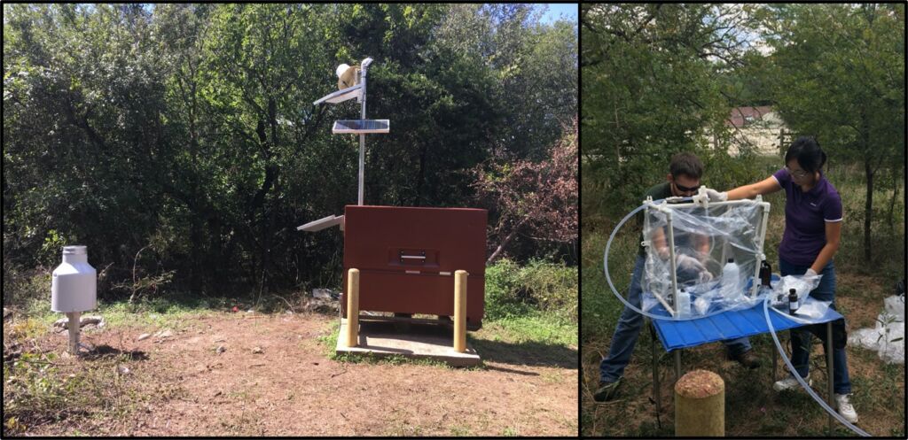
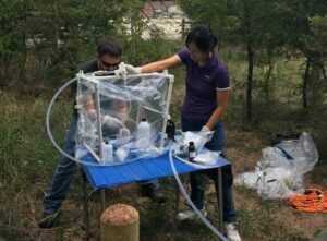
Left: A “super gage” measures surface and groundwater levels and collects rainfall, water quality, and stormwater runoff samples from adjacent streams using an autosampler (that is triggered by water levels indicating stormwater flow). Right: Members of the UHN team collect and process water-quality samples. Photos: USGS
On the Horizon for San Antonio: Water Equity Task Force
As a result of their partnership with the USGS to create the UHN, the San Antonio Urban Waters Federal Partnership has access to reliable data that water resource managers can use for real-world decision-making in a rapidly growing city. Partnerships like this are unique and valuable and help ensure the long-term sustainability of water resources and the integrity of water resources management in the region.
In 2020, the San Antonio River Basin Urban Waters Federal Partnership is embracing the goal of water equity by becoming part of the U.S. Water Alliance’s Water Equity Task Force. SAWS will join this national effort to bring equity into water infrastructure decisions by engaging local utilities, stakeholders and partners to understand water equity issues and to create a roadmap of actions to address them. The ultimate vision is ensuring safe, reliable, and affordable water to all people nationwide.
Sources and Further Reading
USGS Urban Waters Federal Partnership Cooperative Matching Funds Projects:
- Contaminants in the Edwards aquifer: Where do they come from and how do they get there?
- Is Urban Runoff Affecting Groundwater Quality?
- Edwards Aquifer Recharge Zone Surface-water and Groundwater Interaction
More from the USGS:
- Temporal and Spatial Variability of Water Quality in the San Antonio Segment of the Edwards Aquifer Recharge Zone, Texas, With an Emphasis on Periods of Groundwater Recharge, September 2017–July 2019
- Effects of urbanization on water quality in the Edwards aquifer, San Antonio and Bexar County, Texas: U.S. Geological Survey Fact Sheet 2020–3028
- Water-Quality Observations of the San Antonio Segment of the Edwards Aquifer, Texas, With an Emphasis on Processes Influencing Nutrient and Pesticide Geochemistry and Factors Affecting Aquifer Vulnerability, 2010–16
- Source, variability, and transformation of nitrate in a regional karst aquifer: Edwards aquifer, central Texas
- Timescales of water-quality change in a karst aquifer, south-central Texas
More from the Urban Waters Learning Network about the San Antonio River Basin Urban Waters Federal Partnership: